You are here > Home > Inspire Me > Discover Durham's Great Outdoors > Walking > St John's Chapel Walk

About
Distance: 8.75 KM (5.5 miles)Grade of Walk:Moderate
Time:3.5 hours
Stiles:On Route
High up in Weardale, this is a lovely country walk that is not too difficult - apart from a short climb up to Allercleugh Farm - yet rewards with a real sense of being away from the crowds. Following field paths and farm tracks, it gently loops around the upper reaches of the River Wear taking in both open grassy moorland and leafy riverside stretches. This whole area was an important centre of the 19th-century lead mining industry. Go underground at the nearby Killhope Lead Mining Museum to get a sense of the dark, hard-working conditions!
Start / Parking
Recommended Route
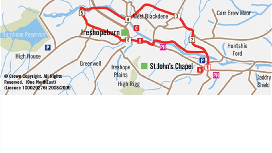
From St. John's Chapel, follow the road beside the Town Hall to Burn Foot. Turn left over a bridge across Harthope Burn then right down over a footbridge across the River Wear. Head up to a 'crossroads' of paths where you turn left to a gate then right up the wooded bank to a house. Follow the track behind the house then, where it bends right, head straight on through a wall gap to a stile in the bottom field corner. Follow the signed path across several fields to join a track.
At the junction of hard surface tracks, head straight on for a few paces then right over a stile, opposite a house gable end. Head up to a gate in the top left field corner then carry on to a road. Turn left and follow the road to reach the second house (after 400 yds) where you turn right through a gate. Head up alongside the wall on your left to reach a Rakes Sike (tumbling stream). Follow the wall curving to the left and keeping stream on your right over rough terrain to a fence-stile, after which carry on alongside the wall through several fields to a road.
Follow the track opposite to reach Allercleugh Farm and a gate just beyond the house. Head across the field to a wall-gate then bear slightly left skirting High Whitestones Farm to join a lane 150 metres below the house. Turn left down to Low Whitestones Farm then, where the lane bends left after the barns, head straight down the field to a stile in the bottom right corner and a road. Take the path opposite through a gate to the left of the house then right along the field boundary to a wall-gate in a "finger" off the main field. Go through the gate, heading down the field (wall to left), then down steps to a passage to the left of cottages (West Blackdene) to join a lane. Turn right at the lane then left over a road-bridge across the Wear.
Immediately after the bridge, turn right along a track to Waterside Farm. Carry straight on across several fields (Wear on right) then along an enclosed riverside path to reach the road through Wearhead. Take the lane opposite ('Water Treatment Works') then, after a few paces, right through a stile/gate. Head alongside the Wear at first then left alongside Burnhope Burn along a riverside path and up over a stile. Head along the top of the riverbank and through a wall-gate in the field corner. Turn left (ignore footbridge) towards the farmhouse then left again through a gate that leads back into the field you just crossed. Head right to a gate and a road.
Head through the gate across the road, bear left through another two gates, and then bear right, up through a field gate in the top corner. Turn up a steep bank, to pass to the left of Low Rigg Farm (ruin). In front of the farmhouse turn sharp left through a gate. Head alongside the wall on your left then, at the 'dog leg', bear right towards the buildings of Irestone over a wall-stile onto a track. Turn right to reach a junction of tracks. Turn left in front of the cottages then, where the track bends left, head right up to a wall-stile in the top far corner of a field into woodland. Head across the top of the woodland to soon emerge at a gate, then carry straight down through several fields alongside the wall on your right. Reaching a track, pass farm buildings to join a country road. Turn left along the road to reach the main A689 through Ireshopeburn.
Turn right along the A689 (pavement) then left before Weardale Museum towards New House to cross Coronation Bridge across the Wear. Immediately after the bridge head right along the riverside path to reach but not cross a ford. Head left along the track (away from ford) for a few paces then right to quickly reach a footbridge. Ignore footbridge but turn left through a stile then right along the field boundary/river to reach a farmhouse. Head left through the farmyard to reach another track - head through the squeeze-stile/gate opposite. Follow the path across several fields to rejoin the 'crossroads' of paths. Turn right over the footbridge at the start of the walk up into St. John's Chapel.
TripAdvisor
Facilities
Accessibility
- Distance: 5-10 Miles
- Grade: Moderate
- Route Surface: Off Road
- Stiles on Route
- Theme: Breathtaking Views
- Theme: Heritage
- Theme: Nature
- Theme: Rivers / Reservoirs
Provider Features
- Distance (6-10 Km)
- Grade (Moderate)
- Time (3-4 hours)
Opening Times
| 2026 (1 Jan 2026 - 31 Dec 2026) |
|---|


 to add an item to your Itinerary basket.
.png)


