

 to add an item to your Itinerary basket.
.png)


You are here > Home > Things to Do > Battle of Neville's Cross Walk Route
Battle of Neville's Cross Walk Route
Toll House Road
Durham
County Durham
DH1 4HU
Durham
County Durham
DH1 4HU
Tel: +44 03000 262626


About
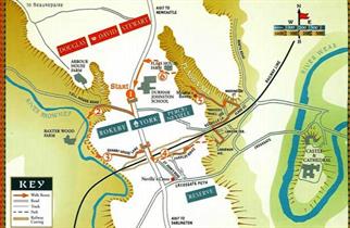
Walking down Toll House Road has taken you between the lines of the two armies; the English on the crest of the low ridge about 150 metres to the south and the Scots to the north.
Look right before turning left off the road towards Baxter Wood. A small valley can be seen to the east of
About
Walking down Toll House Road has taken you between the lines of the two armies; the English on the crest of the low ridge about 150 metres to the south and the Scots to the north.
Look right before turning left off the road towards Baxter Wood. A small valley can be seen to the east of Arbour House Farm. This valley caused a major problem for the Scots (2).
The line of advance of the Scottish right wing under Sir William Douglas took it into this valley where it was hampered by the descent down the steep slopes and the ditches and fences which intersected the land in the valley bottom. Confusion resulted, with the cohesion of the three schiltrons ('hedgehog-like' formations of pikes) lost. The Scots also had to climb the slope in front of Sir Thomas Rokeby's men who were the bulk of the English archers. He re it is possible to see that the English line was sensibly protected from a flank attack by the river and the seep river bluff (3).
As you climb back up to the plateau of Crossgate Moor you are now about 250 metres behind the English line. Quarry House Lane takes you back to the main Newcastle to Darlington road which is again crossed by a footbridge. Follow the main road south and, immediately after crossing the railway bridge over Redhills Cutting, turn left and take a narrow path which firstly takes you to the end of St John's Road and then to Farnley Ridge (4).
The path continues beside the cutting at the far end of Farnley Ridge. Follow the footpath downhill to its Junction with Laburnum Avenue and then right. Take the first turning on the left, and second left again into Lawson Terrace. Walk to the end of the street and turn right and immediately left onto the footpath which climbs to a tunnel under the railway line. Turn right down Redhills Lane (watch for the traffic!) and continue past the Miners' Hall on your left to the bottom of Flass Street. Turn left along Waddington Street and then left again. Continue and turn right into the path leading into Flass Vale (the right hand of the two metalled tracks, signposted 'Private Road - public footpath only'). Follow the path and, about 90 metres past a bungalow, Maiden's Bower - a Bronze Age Barrow - appears on the left (5) .
Continue along the path through Flass Vale and, after about 240 metres on the far side of a clearing, where the trees on either side of the path give way to more open terrain, turn left and climb a path which takes you to Flass House Farm and the fence surrounding Durham Johnston School. As you look over the school playing fields the sire of the last stage of the barrier lies around you (6). The Scots' centre, under the command of King David, was now exposed by the withdrawal of Stewart's division on the left and the defeat of Douglas' division on the right. The English troops closed around the Scottish centre and sheer weight of numbers now began to tell. David's standard bearer was killed and the King himself was wounded before he was eventually captured by John Copeland. The defeated and leaderless remnants of the Scots army's teamed northwards fighting small-scale actions, including one on Findon Hill. King David was taken to a Northumbrian castle for safety and he was eventually handed over to Edward III. He remained in English custody for ll years and was freed in exchange for a 66,000 ransom which is the equivalent of about £15 million in today's terms'- Follow the fence northwards and then westwards back to the main A167. Turn left to get back to the starting point of the walk.
Book Tickets
TripAdvisor
Facilities
Accessibility
- Distance: 1-5 Miles
- Route Surface: Off Road
- Route Surface: On Road
Parking & Transport
- On site parking
Provider Features
- Outdoor Attraction
- Village Location
Access Information
Opening Times
| 2025 (1 Jan 2025 - 31 Dec 2025) |
|---|


